Blueprint Atlas: The Google Maps Style Revolutionizing Architectural Design
Unveiling a new era of precision cartography, tailored for the discerning eye of architects and interior designers.
Blueprint Atlas: The Google Maps Style Revolutionizing Architectural Design
Unveiling a new era of precision cartography, tailored for the discerning eye of architects and interior designers.
For architects, interior designers, and urban planners, a map is more than just a guide; it's a foundational canvas, a critical data source, and often, the very first impression of a project's context. Yet, standard mapping solutions, designed for general navigation, frequently fall short. They are often cluttered with irrelevant points of interest, vibrant colors that distract, and a visual hierarchy ill-suited for the nuanced demands of design professionals. The need for specialized cartography, one that speaks the language of design, has never been more apparent.
This is where Blueprint Atlas emerges – a groundbreaking Google Maps style meticulously engineered to meet the exacting standards of the architectural and design community. It's not just a new look; it's a new lens through which to view, analyze, and present the spatial context of your most ambitious projects.
The Vision Behind Blueprint Atlas: Precision Meets Aesthetics
Blueprint Atlas isn't just another map style; it's a meticulously engineered visual language crafted for professionals who demand clarity, functionality, and aesthetic refinement in their spatial data. Our persona is clear: architects and interior designers who require a clean, highly functional, and aesthetically refined spatial context for their projects. They need to quickly discern structural elements, site conditions, and material relationships without visual clutter.
Our brief was to create a Google Maps visual style engineered for precision and clarity, specifically catering to the demanding needs of architectural and interior design professionals. Blueprint Atlas strips away visual distractions, emphasizing structural forms, topographical nuances, and the intricate urban fabric. The style promotes a focused analytical view, enabling designers to integrate their projects seamlessly within their spatial environment, from the initial site analysis to the final client presentation.
Key Design Principles: Clarity, Hierarchy, and Professionalism
Every element within Blueprint Atlas is a deliberate choice, guided by a set of core design principles that prioritize the professional user's needs:
- Minimizing visual noise for enhanced focus: Gone are the distracting tourist attractions and overly vibrant POIs. Blueprint Atlas presents only the most relevant information, allowing designers to concentrate on the critical aspects of their site.
- Prioritizing structural and topographical data: Buildings, roads, waterways, and elevation changes are rendered with a clarity that highlights their form and relationship, essential for site planning and environmental integration.
- Subtle, sophisticated color palette for professional use: The chosen palette is understated yet highly effective, ensuring that the map complements, rather than competes with, your design work.
- Clear differentiation of urban elements: Roads, pedestrian paths, green spaces, and building footprints are distinct yet harmoniously integrated, providing an immediate understanding of the urban context.
- Optimized for print and digital presentation: Whether projected on a screen or printed for a board meeting, Blueprint Atlas maintains its crispness and legibility, ensuring professional-grade output every time.
- Scalability for various zoom levels, maintaining detail: From a bird's-eye view of an entire city to a detailed street-level perspective, the style intelligently adapts, revealing appropriate levels of detail without becoming overwhelming.
- Intuitive hierarchy of information: Important features stand out naturally, guiding the eye to critical data points without the need for explicit labels or heavy-handed styling.
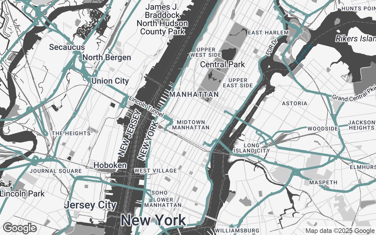
Palette Deep Dive: Colors that Communicate, Not Distract
Blueprint Atlas employs a masterclass in understated elegance. The palette is carefully curated to communicate information effectively without overwhelming the senses. It's a symphony of muted tones designed to provide a sophisticated backdrop for your architectural visions.
- Neutrals (
#F5F5F5,#D0D0D0,#808080,#606060): These form the backbone of the style, providing a clean, unobtrusive base for land, water, and less prominent features. They ensure that the map feels grounded and professional, allowing your project's details to take center stage. - Primary (
#4A4A4A): A strong, yet not harsh, dark grey used for primary roads, building outlines, and key structural elements. This color provides essential contrast and definition, guiding the eye to the most significant features. - Secondary (
#A0A0A0): A lighter grey that supports the primary color, used for secondary roads, less prominent structures, and textual labels. It maintains visual harmony while providing necessary differentiation. - Accent (
#5F8B8B): A subtle, sophisticated teal. This is the only color that truly stands out, reserved for highlighting specific features like parks, water bodies, or points of interest that require gentle emphasis. It adds a touch of modern elegance without being garish.
This palette ensures that the map is not only functional but also aesthetically pleasing, aligning with the refined tastes of design professionals.
Feature Focus: How Blueprint Atlas Prioritizes Design-Relevant Data
Blueprint Atlas is engineered to highlight what truly matters to architects and designers. Gone are the distracting tourist attractions and overly vibrant points of interest. Instead, the style emphasizes:
- Building Footprints and Massing: Clearly defined building outlines and subtle shading provide an immediate understanding of urban density and context.
- Topographical Contours: Where available, elevation changes are rendered with precision, crucial for site grading, drainage analysis, and understanding the natural landscape.
- Road Networks and Pedestrian Paths: Differentiated with clarity, allowing for easy analysis of access, circulation, and urban flow.
- Green Spaces and Water Bodies: Rendered with the subtle accent color, these elements are easily identifiable, aiding in environmental impact assessments and landscape design.
- Property Lines (where data allows): Presented with a clean, unobtrusive line style, essential for site planning and legal considerations.
Practical Applications: From Site Analysis to Client Presentations
Blueprint Atlas is more than just a pretty map; it's a powerful tool that integrates seamlessly into various stages of the design process:
- Initial Site Analysis: Quickly identify critical site conditions, adjacencies, and environmental factors.
- Urban Planning & Contextual Studies: Understand the broader urban fabric, traffic flow, and pedestrian movement patterns.
- Sun Path and Shadow Studies: The clean background makes it easier to overlay and visualize solar impacts.
- Material Sourcing & Logistics: Identify access points, delivery routes, and local resources.
- Client Presentations: Present your project within a sophisticated, professional spatial context that enhances credibility and understanding.
- Permitting & Regulatory Submissions: Provide clear, legible maps that meet professional standards.
Integration and Customization: Leveraging Google Styled Maps
Blueprint Atlas is built upon the robust and flexible Google Maps Platform's Styled Maps feature. This means integration into your existing workflows is straightforward. Whether you're embedding maps into a web application, using them in a GIS software, or exporting for print, Blueprint Atlas can be easily applied. The underlying Google Maps API ensures global coverage, up-to-date data, and reliable performance, all while presenting it through a lens specifically crafted for design professionals. Furthermore, while Blueprint Atlas offers a perfected default, the flexibility of Styled Maps allows for minor customizations should a project require a unique emphasis on certain features.
The Future of Spatial Context in Architecture and Interior Design
As design continues to evolve, so too must the tools that support it. Blueprint Atlas represents a significant leap forward in providing architects and interior designers with the spatial context they truly need. It's about empowering professionals to make more informed decisions, present their work with greater clarity, and ultimately, design better environments. This new style isn't just an improvement; it's an essential evolution, setting a new standard for how design professionals interact with the world around their projects.
Case Studies: Real-World Impact of Blueprint Atlas
Early adopters of Blueprint Atlas have already reported significant improvements in their project workflows. From urban revitalization projects in bustling city centers to serene residential developments in suburban landscapes, the clarity and precision offered by Blueprint Atlas have streamlined site analysis, enhanced client communication, and elevated the overall professionalism of their presentations. These real-world applications underscore the transformative power of a mapping style truly designed for the discerning eye of the architect and designer.