SpatialCanvas: Redefining Google Maps for Architectural Precision
A minimalist, CAD-inspired visual style designed to empower architects and interior designers with unparalleled clarity and contextual understanding for site analysis and urban planning.
SpatialCanvas: Redefining Google Maps for Architectural Precision
A minimalist, CAD-inspired visual style designed to empower architects and interior designers with unparalleled clarity and contextual understanding for site analysis and urban planning.
For too long, design professionals have grappled with the limitations of standard mapping tools. While invaluable for navigation, the default Google Maps experience, with its vibrant colors and dense points of interest, often introduces visual clutter that hinders the precise analysis crucial for architectural and urban design. Architects, interior designers, and urban planners need more than just a map; they need a foundational canvas that speaks their language – a tool that prioritizes clarity, precision, and contextual understanding without overwhelming the eye.
Introducing SpatialCanvas, a revolutionary Google Maps style meticulously crafted for the discerning professional. SpatialCanvas transforms Google Maps into a sophisticated, minimalist instrument, stripping away visual noise to highlight essential urban and topographic data. It's not just a new look; it's a new way to see the world through a designer's lens, providing a clean, adaptable background for detailed spatial analysis and informed design decisions.
Core Philosophy: Clarity, Precision, and Context
At the heart of SpatialCanvas lies a commitment to design principles that resonate deeply with the architectural profession. Every element, every line, and every shade has been carefully considered to serve a singular purpose: to empower designers.
- Clarity Over Clutter: We prioritize essential data, minimizing extraneous visual noise. This means fewer distracting labels, simplified icons, and a focus on the fundamental elements that define a site.
- Precision & Accuracy: Emphasizing crisp lines and defined boundaries, SpatialCanvas ensures that building footprints, road networks, and property lines are rendered with the accuracy needed for detailed analysis and conceptual design.
- Contextual Awareness: While minimalist, SpatialCanvas doesn't sacrifice context. Subtle yet informative topographic features, water bodies, and green spaces are rendered to provide a comprehensive understanding of the site's environment.
- Harmonious Integration: The map serves as a neutral, adaptable background, designed to seamlessly integrate with your design overlays, sketches, and 3D models without competing for attention.
- Hierarchical Information: Visual weight and color are subtly employed to guide attention to key elements, ensuring that critical information is easily discernible without being overtly highlighted.
The SpatialCanvas Aesthetic: A CAD-Inspired Look
Imagine the clean lines and understated elegance of a technical drawing, now applied to the vastness of Google Maps. That's the SpatialCanvas aesthetic. We've adopted a professional, understated look reminiscent of CAD software, where every line has purpose and every shade contributes to legibility rather than distraction. This minimalist approach ensures that the map acts as a true canvas, ready to be layered with your creative vision.
Key Features for Architects: Building Footprints and Topography
SpatialCanvas is engineered with the specific needs of architects and urban planners in mind, offering features that directly enhance site analysis and project development:
- Defined Building Footprints: Clearly delineated building outlines provide immediate understanding of existing structures, their scale, and their relationship to the surrounding urban fabric.
- Subtle Topographic Contours: Elevation changes are rendered with a delicate touch, offering crucial insights into site grading, drainage, and potential views without overwhelming the visual field.
- Streamlined Road Networks: Roads are presented with a simplified, hierarchical structure, making it easy to discern major arteries from local streets, aiding in traffic flow analysis and access planning.
- Water Bodies and Green Spaces: Parks, rivers, and lakes are rendered with a calming, consistent palette, providing essential environmental context.
Palette Breakdown: Why Our Colors Enhance Focus
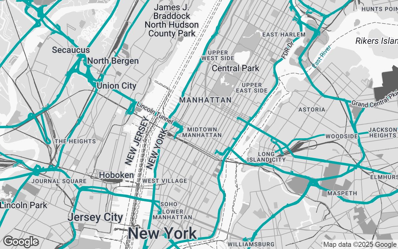
The color palette of SpatialCanvas is a deliberate choice, designed to enhance focus and reduce visual fatigue. We've moved away from the vibrant, often overwhelming hues of standard maps to a sophisticated, muted scheme:
- Primary Background (
#F8F8F8): A near-white, soft background provides a clean, neutral base, ideal for overlaying design elements without color clashes. - Secondary Background (
#C0C0C0): Used for less prominent areas or subtle distinctions, offering gentle contrast. - Neutrals (
#E0E0E0,#A0A0A0,#606060,#303030): A gradient of grays defines roads, building outlines, and other structural elements, creating depth and hierarchy without relying on strong colors. Lighter grays for less important features, darker grays for primary lines. - Accent (
#008080): A subtle, professional teal is reserved for specific, critical highlights – perhaps water bodies or key points of interest when activated – providing a touch of distinction without being obtrusive. This color is chosen for its calming effect and professional appeal.
This carefully curated palette ensures that the map remains a background, a tool, rather than a dominant visual element, allowing your design work to take center stage.
Optimizing for Site Analysis and Urban Planning
SpatialCanvas is more than just a pretty map; it's a powerful analytical tool. For site analysis, it provides an immediate, uncluttered view of:
- Urban Fabric: Understand the density, block structure, and pedestrian pathways of a neighborhood.
- Zoning Context: While not explicitly showing zoning, the clear delineation of parcels and building footprints provides an excellent base for overlaying such data.
- Environmental Factors: Quickly assess the relationship between your site and natural features like waterways, parks, and elevation changes.
For urban planning, it facilitates initial conceptualization, master planning, and understanding the broader implications of development within a city's existing infrastructure.
Seamless Integration into Design Workflows
We understand that designers operate within complex ecosystems of software. SpatialCanvas is built with adaptability in mind, ensuring it can be easily integrated into various design workflows and presentations. Whether you're exporting a base map for CAD drawings, using it as a reference in GIS software, or incorporating it into client presentations, its clean aesthetic ensures consistency and professionalism across all platforms. The minimalist design makes it an ideal backdrop for digital sketching, 3D modeling, and rendering, allowing your proposed designs to stand out clearly.
Beyond Navigation: A Tool for Informed Decision-Making
SpatialCanvas elevates Google Maps beyond a mere navigation aid, transforming it into an indispensable tool for informed decision-making. By providing a clear, precise, and context-rich view of any site, it empowers architects and designers to:
- Accelerate Conceptual Design: Quickly grasp site conditions and develop initial concepts with greater confidence.
- Enhance Presentations: Present site analysis and design proposals with a professional, sophisticated base map that reinforces your expertise.
- Improve Collaboration: Ensure all stakeholders are viewing the same, uncluttered, and relevant spatial data.
Future Enhancements and Community Feedback
SpatialCanvas is an evolving platform. We are committed to continuously refining and expanding its capabilities based on the needs of the design community. Future enhancements may include additional data layers, further customization options, and deeper integration with popular design software. We invite architects, interior designers, and urban planners to experience SpatialCanvas and provide feedback, helping us shape the future of professional mapping for the built environment. Your insights are invaluable as we continue to redefine how designers interact with the world around them.