Spatial Sense: Redefining Google Maps for Architectural Precision
A deep dive into a minimalist, functional, and aesthetically refined cartographic style tailored for design professionals.
Spatial Sense: Redefining Google Maps for Architectural Precision
A deep dive into a minimalist, functional, and aesthetically refined cartographic style tailored for design professionals.
Introduction: The Need for Designer-Centric Maps
For too long, architects, interior designers, and urban planners have navigated the digital landscape of mapping tools with a sense of compromise. Standard Google Maps, while invaluable for general navigation, often present a cacophony of visual information – tourist attractions, commercial icons, and photographic textures – that can obscure the very details critical to design professionals. What's needed is a tool that transcends mere wayfinding, transforming into an environment for conceptualization, site analysis, and spatial understanding.
Enter Spatial Sense, a revolutionary new Google Maps style meticulously crafted for the discerning eye of the design professional. Spatial Sense strips away the visual noise, offering a clean, precise, and aesthetically refined map view that emphasizes spatial relationships, structural context, and the foundational elements of urban and interior environments over photographic realism. It's not just a map; it's an indispensable design companion.
Core Philosophy: Clarity, Precision, and Context
At the heart of Spatial Sense lies a profound understanding of the design process. Our core philosophy is built upon a set of principles designed to empower architects and designers:
- Clarity over Clutter: Every element is purposeful, eliminating distractions to highlight what truly matters.
- Geometric Precision: Forms are rendered with crisp lines and accurate representations, crucial for dimensional understanding.
- Materiality through Abstraction: While not photographic, the style subtly suggests material differences, aiding in contextual analysis.
- Subtle Hierarchy: Information is layered intelligently, guiding the eye without overwhelming it.
- Contextual Awareness: The map provides a rich backdrop for design interventions, emphasizing surrounding structures and natural features.
- Professional Aesthetic: A sophisticated and understated visual language that resonates with design sensibilities.
- Scalable Detail: Whether zooming in on a building facade or pulling back for urban planning, the level of detail adapts intelligently.
This approach ensures that the map serves as a highly informative yet visually calm canvas, enabling users to quickly grasp site context, analyze spatial flow, and envision design interventions with enhanced precision.
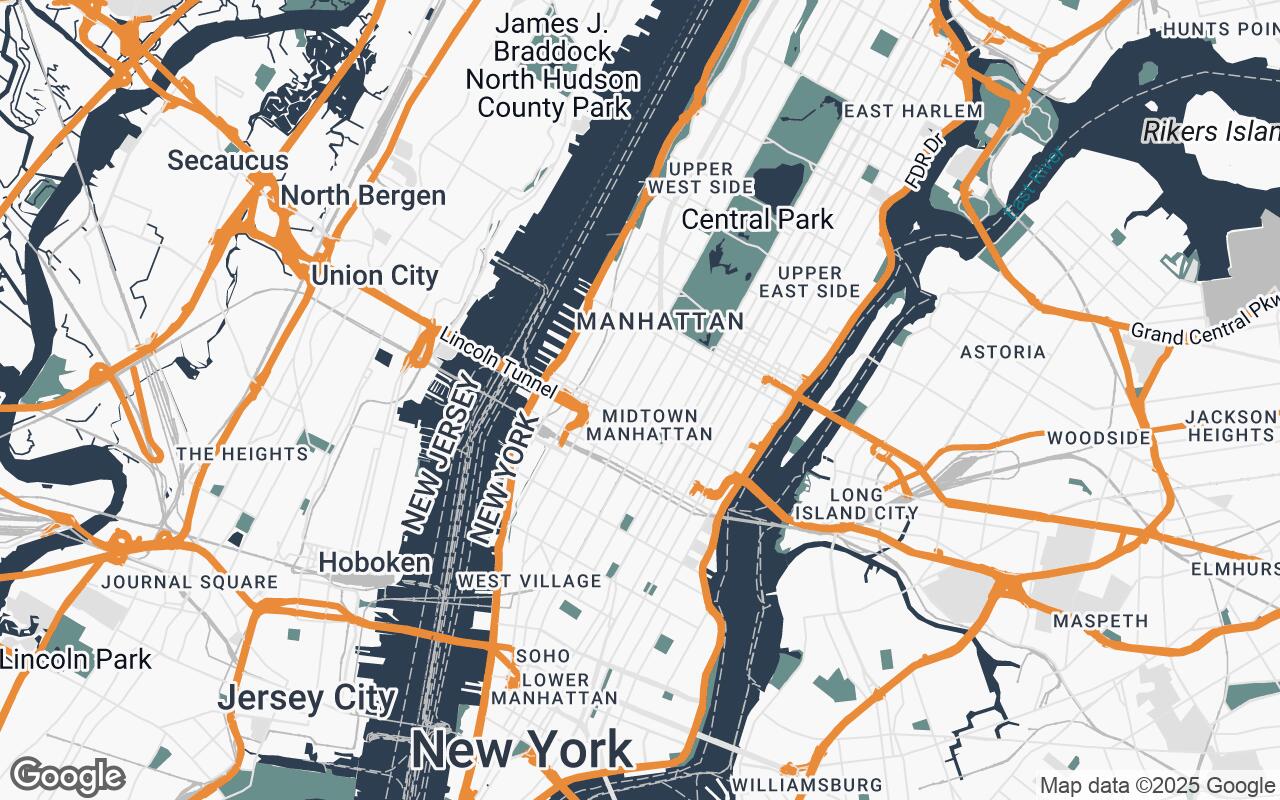
Understanding the Spatial Sense Palette: A Symphony of Neutrals and Accents
The visual power of Spatial Sense emanates from its carefully curated color palette. Moving beyond the vibrant, often distracting hues of conventional maps, Spatial Sense employs a sophisticated spectrum designed for professional use:
- Neutrals: A range of cool grays (
#F8F8F8,#E0E0E0,#BDBDBD,#8D8D8D) form the backbone, providing a serene backdrop for all information. These varying shades subtly differentiate land use, topography, and less prominent structures without drawing undue attention. - Primary: A deep, authoritative
#2C3E50(dark blue-gray) is used for primary roads, significant building outlines, and key structural elements, establishing a clear visual hierarchy. - Secondary: A calming
#698F8C(teal-gray) provides a complementary tone, often used for water bodies, parks, or secondary pathways, adding depth without visual conflict. - Accent: A judicious touch of vibrant
#E67E22(burnt orange) is reserved for critical points of interest, user-defined markers, or specific data overlays, ensuring that important information immediately stands out without dominating the overall aesthetic.
This palette is not merely decorative; it's a functional system that enhances readability, reduces eye strain, and allows for rapid information processing.
Geometric Abstraction: Interpreting Urban Form
One of the defining features of Spatial Sense is its approach to geometric abstraction. Instead of attempting photographic realism, the style renders buildings and urban elements with clean, simplified geometric forms. This deliberate abstraction offers several advantages for designers:
- Clarity of Massing: Easily discern building footprints, volumes, and relationships without distracting facade details.
- Boundary Definition: Crisp lines clearly delineate property lines, public spaces, and private zones.
- Spatial Relationships: Understand how structures relate in terms of proximity, alignment, and orientation at a glance.
This method transforms complex urban fabric into an easily interpretable diagram, perfect for early-stage conceptual design and site analysis.
Layering Information: What to See and What to Hide
Spatial Sense excels in its intelligent layering of information. Unlike general-purpose maps that display everything by default, this style prioritizes architectural relevance. Non-essential elements are minimized or entirely removed, ensuring that the map remains focused on key data points for design professionals:
- Essential Infrastructure: Roads, pathways, and public transport lines are clearly depicted.
- Building Footprints & Massing: Core to understanding site context and potential interventions.
- Topography & Natural Features: Contours and green spaces are rendered with subtle clarity.
- Utility & Zoning Overlays: (Future potential) Allowing for custom data integration crucial for planning.
This selective display reduces cognitive load, allowing designers to concentrate on their specific analytical or creative tasks.
The Role of Labels: Guiding Without Distracting
Labels in Spatial Sense are designed to inform, not to overwhelm. A minimalist approach ensures that text elements provide necessary identification without cluttering the visual field. Key characteristics include:
- Subtle Typography: A clean, legible sans-serif font that integrates seamlessly with the map's aesthetic.
- Contextual Placement: Labels are intelligently positioned to avoid overlapping features.
- Hierarchical Sizing: Important labels are slightly more prominent, while less critical ones recede gracefully.
This careful balance ensures that users can quickly identify streets, neighborhoods, and key landmarks without their attention being diverted from the underlying spatial data.
3D Context: Leveraging Extrusion for Site Analysis
Understanding the three-dimensional context of a site is paramount in architecture. Spatial Sense leverages Google Maps' 3D building data, rendering structures with subtle extrusion to provide essential massing information. This feature is invaluable for:
- Shadow Studies: Gaining an intuitive sense of how sunlight will interact with proposed designs.
- Scale Perception: Accurately gauging the relative height and bulk of surrounding buildings.
- Urban Canyon Effects: Analyzing how existing structures define streetscapes and public spaces.
This 3D capability transforms the map into a dynamic model, aiding in environmental analysis and conceptual visualization.
Beyond Navigation: Maps as a Design Tool
Spatial Sense redefines the map from a mere navigation aid into a powerful, active design tool. It's an environment where ideas can germinate and evolve:
- Conceptual Sketching: Use the clean backdrop for overlaying initial design ideas.
- Site Feasibility: Rapidly assess a site's potential and constraints.
- Client Presentations: Present design proposals within a clear, professional, and contextually rich map environment.
- Urban Planning: Visualize zoning, infrastructure, and public spaces with unprecedented clarity.
It fosters a deeper engagement with the built environment, making the map an extension of the designer's workspace.
Case Studies: Applying Spatial Sense in Practice
Imagine an architect evaluating a potential urban infill site. With Spatial Sense, they can instantly visualize the building's footprint, its relationship to adjacent structures, and the flow of pedestrian and vehicular traffic, all without the distraction of tourist icons or satellite imagery. An interior designer planning a new retail space can use the style to understand the surrounding streetscape and how it influences the building's facade and entry points.
Consider an urban planner assessing a new park development. Spatial Sense provides a clear view of existing green spaces, water bodies, and surrounding residential zones, allowing for a holistic understanding of the ecological and social context. The minimalist aesthetic ensures that the focus remains on the spatial relationships, not on extraneous visual detail.
Future Developments and Customization Potential
Spatial Sense is an evolving platform. We envision future developments that will further empower design professionals:
- Custom Data Overlays: The ability to import and visualize proprietary data layers (e.g., zoning maps, utility lines, demographic data).
- Integration with Design Software: Seamless export or direct integration with popular CAD and BIM applications.
- Thematic Styling Options: Further customization of the palette and feature display for specific project types (e.g., landscape architecture, historical preservation).
The potential for Spatial Sense to become an even more deeply integrated part of the design workflow is immense, offering unparalleled flexibility and precision.
Conclusion
Spatial Sense represents a paradigm shift in how design professionals interact with digital maps. By prioritizing clarity, precision, and an uncompromised aesthetic, it transforms Google Maps into an indispensable tool for conceptualization, analysis, and presentation. It's time to elevate your spatial understanding and refine your design process with a map style crafted specifically for you. Experience the difference that true Spatial Sense can make in your next project.