Spatial Canvas: Redefining Google Maps for Architectural Vision
A bespoke visual style designed to empower architects and interior designers with unparalleled clarity and contextual insight.
Spatial Canvas: Redefining Google Maps for Architectural Vision
A bespoke visual style designed to empower architects and interior designers with unparalleled clarity and contextual insight.
For architects, interior designers, and urban planners, the foundational understanding of a site is paramount. It’s the canvas upon which every vision is built, the context that shapes every line and volume. Yet, for too long, the default mapping tools, while incredibly powerful for general navigation, have fallen short of the specific, nuanced demands of the design professional.
Standard Google Maps, with its vibrant palette and emphasis on routes and points of interest, often introduces visual noise that obscures the very spatial relationships and material potentials that designers seek to uncover. It’s like trying to sketch on a pre-colored, busy background – distracting and counterproductive. We recognized this critical gap, and from it, Spatial Canvas was born.
Introducing Spatial Canvas: Your Design-Centric Map
Spatial Canvas transforms Google Maps into a sophisticated, indispensable tool tailored specifically for the design community. Our core philosophy is simple: provide a clean, precise, and aesthetically refined base map that emphasizes spatial relationships, material potential, and contextual understanding. It’s engineered to elevate your site analysis, urban planning, and conceptualization processes, making it an essential resource from the first sketch to the final presentation.
The Core Philosophy and Design Goals:
- Clarity First: We strip away visual clutter, presenting only the most relevant data with immediate legibility. Every element serves a purpose, enhancing understanding, not hindering it.
- Hierarchical Emphasis: Key architectural and urban elements – buildings, public spaces, infrastructure – are subtly highlighted, ensuring that the critical components of the urban fabric are instantly discernible without overwhelming the view.
- Muted Palette: A professional, non-distracting color scheme allows your design concepts to take center stage. This neutral foundation ensures that your overlays and proposals pop, rather than competing with the map itself.
- Material Resonance: Subtle textures and colors hint at the underlying material qualities of surfaces and structures, offering a richer, more intuitive understanding of the built environment.
- Contextual Awareness: Spatial Canvas provides essential urban fabric details without the visual noise, allowing designers to grasp the surrounding environment’s character and scale effortlessly.
- Precision & Detail: Sharp lines, legible labels, and accurate representations are paramount, supporting the precise interpretation required for professional design work.
- Adaptable Base: The style is designed to be a neutral, intelligent backdrop, perfect for overlaying your own design proposals, analyses, and presentations.
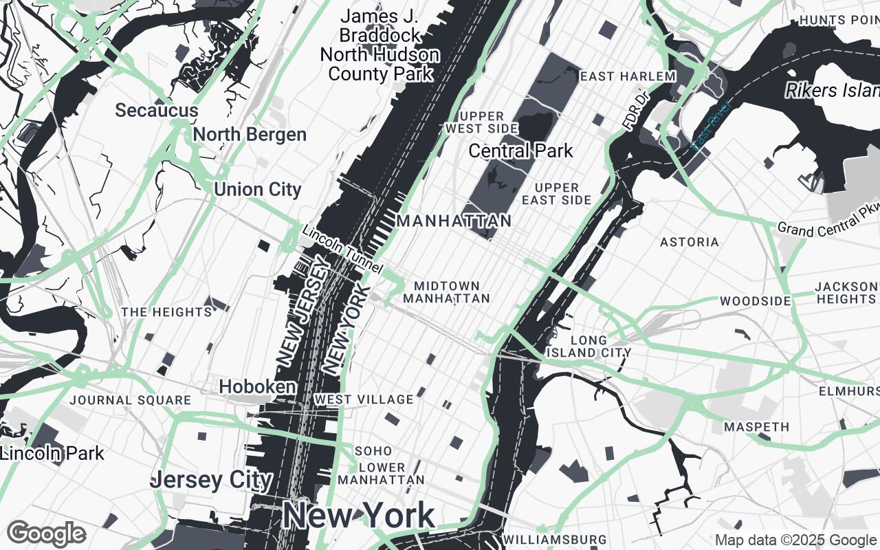
Deconstructing the Palette: Key Visual Elements
Our choice of colors and styling is meticulously crafted to serve the design professional. The Spatial Canvas palette is a thoughtful departure from the consumer-oriented mapping aesthetic.
- Primary (#2A2F36) & Secondary (#4E5560): These deep, sophisticated tones form the backbone of the map, defining landmasses, major roads, and significant structures. They provide a grounding presence without being visually heavy.
- Neutrals (#F8F8F8, #E0E0E0, #C8C8C8, #A0A0A0): A gradient of grays and off-whites creates depth and distinction between different urban elements – from building footprints to pedestrian zones and water bodies. This nuanced layering allows for clear differentiation while maintaining a cohesive, understated look.
- Accent (#A3D9B5): A carefully selected, subtle green acts as a gentle accent, drawing attention to natural features, parks, and green spaces. It introduces a touch of organic life without disrupting the overall professional aesthetic.
This palette, combined with refined typography and precise linework, creates a map that is both highly functional and aesthetically pleasing, a true extension of the designer's toolkit.
Enhancing Site Analysis: Beyond the Surface
Spatial Canvas fundamentally transforms the site analysis process. No longer do you need to mentally filter out irrelevant information; the map presents the urban context in a way that directly supports your design inquiry.
- Urban Context Clarity: Instantly grasp the density, scale, and rhythm of the surrounding built environment. Identify key arterial routes, pedestrian flows, public transport links, and open spaces with unprecedented clarity.
- Material Understanding: The subtle visual cues hint at material qualities, allowing designers to infer existing textures, finishes, and construction types, which is crucial for contextual integration and material selection for new projects.
- Spatial Relationships: By minimizing visual distractions, Spatial Canvas highlights the crucial relationships between buildings, public realm, and natural features. Understand setbacks, massing, and the interplay of volumes more intuitively.
Beyond Navigation: Leveraging the Map for Conceptual Design and Client Presentations
Spatial Canvas isn't just for analysis; it's a powerful platform for conceptualization and communication.
- Conceptual Design: Use it as a clean base to sketch directly upon, whether digitally or by printing. The muted background ensures that your design proposals – whether a new building footprint, a landscape intervention, or an interior layout within an existing shell – stand out clearly.
- Client Presentations: Present your projects with a sophisticated, professional backdrop. Overlay your 3D models, master plans, or interior schemes onto a map that enhances, rather than detracts from, your vision. The professional aesthetic of Spatial Canvas elevates the perceived quality of your entire presentation.
Integration & Customization: Applying Spatial Canvas to Your Workflow
Integrating Spatial Canvas into your existing workflow is seamless. Available as a custom style for Google Maps Platform, it can be easily applied to web applications, interactive kiosks, or static map exports. Developers and designers can leverage the Google Maps APIs to implement Spatial Canvas, ensuring consistency across all your digital touchpoints. Further customization options allow for fine-tuning specific elements to match your firm's branding or project requirements.
Case Studies: Real-World Applications
- Urban Redevelopment Master Plan: An architecture firm utilized Spatial Canvas to present a complex master plan for a brownfield site. The map's clarity allowed stakeholders to immediately understand the proposed new street grid, green spaces, and building envelopes without being distracted by existing, irrelevant map features. The muted palette made the vibrant proposed design elements pop, facilitating clearer discussions.
- Boutique Hotel Interior Design: An interior design studio used Spatial Canvas to contextualize their design for a new hotel within a historic district. By overlaying the hotel's floor plans onto the Spatial Canvas map, they effectively demonstrated how the interior design drew inspiration from the surrounding urban fabric, considering views, pedestrian access, and the architectural heritage of neighboring buildings. The map’s precision aided in material selection that resonated with the locale.
The Future of Design Mapping: Evolving Tools for Creative Professionals
Spatial Canvas represents a significant step forward in providing specialized tools for the design industry. As our cities grow more complex and our projects more intricate, the demand for intelligent, context-aware mapping solutions will only increase. We are committed to continually evolving Spatial Canvas, integrating new data layers and functionalities that further empower architects, designers, and urban planners to visualize, analyze, and create with unprecedented insight.
Conclusion: Elevating Design with Intelligent Cartography
Spatial Canvas is more than just a map style; it's a strategic design partner. It’s an intelligent cartographic solution that understands the unique needs of creative professionals, offering unparalleled clarity, contextual depth, and aesthetic refinement. By providing a clean, precise, and professional foundation, Spatial Canvas empowers you to focus on what you do best: designing the future. Experience the difference and transform your approach to site analysis, conceptualization, and client communication. Elevate your design with Spatial Canvas.